Saturday, June 11, 2011

Cranberry Wilderness - Prelude to a Trip Report

Just a quick note here, I've just about gotten my GPX files from my trip to the Cranberry Wilderness squared away. There was quite a bit of cleaning up that I had to do with the data and I only have the tracks broken down by day. My next feat will be cutting the tracks up into trail sections.

Anyway I just thought I would share a couple of pictures from GPSVisualizer with you. Here's the overview of the hike we took:

The Cranberry Wilderness
Here's the elevation profile for the entire hike:

The different colors indicate the day of the hike.
Here's the full GPX data for our hike:

Cranberry.gpx

I hope this wets your appetite! Look for a full trail report soon!

~Lateralus

Friday, June 10, 2011

Low Cost Kayak Roof Rack Solution for Naked Roof Cars


I recently decided that I wanted to be able to carry two kayaks on my car, so that I could easily take a friend or my fiance paddling with me. I considered a lightweight trailer, but ruled them out due to cost and storage hassles. That left a roof rack.

If you drive a car with integrated rack rails, that's pretty easy - you can get fairly inexpensive crossbars that attach to your integrated rack. You can then add J-shaped cradles that let your boats rest on edge.

If, however, you drive a car with a "naked roof" - no rack rails, no rain gutters, just a smooth top - you have an issue. You must find a way to add crossbars where there is no existing structure. Yakima and Thule both make systems that fit a wide variety of cars, but they are expensive. I drive a 2002 Ford Taurus and I didn't wish to spend the $700+ that a crossbar/riser /J-cradle system would cost from one of the big names.

I poked around on Amazon, and quickly found that there are knockoffs available - "Universal fit" rack kits, priced as low as $30. Additionally, there are generic J-cradles that go for about $67 per set. This brought up a couple questions - would the rack fit my car, and would the J-cradles fit the rack? Would my handcrafted strip-built kayak come off my car, explode into 10,000 splinters, and kill innocent bystanders? These are things of nightmares.

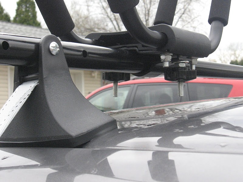
The universal rack is rated to 150 lbs. It isn't the most impressively built piece of equipment I've ever owned, but it does the job - the crossbars are steel, on plastic risers.


I did some reading and found that the universal rack didn't fit the Taurus as designed. It comes with metal clips that are supposed to hook into the door frame. I eventually decided to run cargo straps through the passenger compartment, rather than relying on the hooks. It's very strong, and very cheap - but it comes with two drawbacks.

First, the straps compress the door gasket, which could eventually damage it. I decided I didn't care, because, frankly, it's a 2002 Taurus. My previous method of carrying my kayak involved using a foam block kit and ran the straps through the compartment as well, so that was a wash for me. Your mileage may vary.

Second, it takes a couple minutes to take on and off the car. I decided that both were worth it, since I might only use the system a few times a month.

With that modification, the universal rack was very firmly attached to the top of the car. I ordered a single J-cradle to make sure that it fit the universal rack - it did, quite well. I was very pleasantly surprised at the build quality on the J-cradles at that price point - the are well designed and feel like quality.

My boats both fit the J-cradles fine - a 17 ft Siskiwit Bay and a 15 ft plastic Epitour. I secure the boats to the cradle with the nylon straps supplied with the cradle, and a bow line tied off to the underside of the car. I've since purchased the second J-cradle and await a little free time to install it.


This rack is clearly an exercise in trade-offs. You trade the straps coming through the passenger compartment and possible gasket wear against a nearly $600 difference in price. For occasional use over modest distances, it works well. As an added bonus, the J-cradles will be reusable when I buy a new vehicle with integrated rails. For a total price of $160 I am quite pleased with the results and hope that someone else will find this useful.

Thursday, June 9, 2011

Occasional Hyker is expanding!

Hi everyone!

Just a quick post here to let you know that I made it through my Cranberry Wilderness trek two weeks ago. I have yet to write the trail review, that's coming soon, but I need to clean up my GPS data and organize my pictures first. School is about to end for this quarter and I've been extremely busy because of that.

The North Fork of the Cranberry River - Cranberry Wilderness

I also have some exciting news! My good friend J whom I've talked about on here before has decided to join the blog to document some of his outdoor gear projects. His outdoor hobbies run the gamut from paddling to backpacking. Currently he is learning to make his own light to ultralight gear.

Once we get everything sorted on the site he will be posting so stay tuned for that.

Have a good one and we'll be talking soon!

~Lateralus

Monday, May 23, 2011

T-Minus 52 hours and counting

Good evening friends. I apologize for the delay in posting but again, life gets in the way. This is just a quick note before I go on a trip this weekend to the Cranberry Wilderness in Pocahontas County, West Virginia. I'm planning to hike for four days and I cannot be more excited.

I was reflecting upon all of the gear I have acquired in the past two years and I have come to realize that I am married to a wonderful woman.  She has patiently walked around backpacking and outdoor stores from Cleveland, Ohio to Wheeling, West Virginia while I spent our money on my hobby.  It's hard to find a good understanding woman and I feel blessed to have her.

So, gear. Yes, I have updated nearly all of the gear I had before I returned to backpacking in 2009. My sleeping bag and tent are the only items I have not replaced.

There's something about 'going lighter' that is sort of infectious. I suppose it is similar to buying a new television. You think about getting a new, bigger television, you don't really need one, but you start looking. You find an advertisement at some electronics store for a really good price that you could afford, say $800. Hey, that's not bad, you can afford that. So you buy the new Hi-Def 3D Super View television get it home and realize that your old DVD player and DVD collection just doesn't do the new screen justice. So you go out and upgrade to a BlueRay or whatever is newest. Then, of course you need new movies.  So you start watching your new movies in your new player on your new television and you realize that the old stereo receiver isn't Dolby compatible and all of your movies feature surround sound, so you upgrade the receiver... and on and on.

This is how an $800 deal on a new television ends up costing you $10,000. Deciding to go lighter with your equipment is very similar.

So I'll soon set out on a backpacking trip with a new backpack, a hydration bladder, GPS, new sleeping pad, new boots... the list keeps going.

The loop I'm taking is similar to the loop found on MidAtlanticHikes.com for the Cranberry. I modified it a bit and depending upon trail and weather conditions when we get there, I may modify it some more. Of course I'll be taking along the old digital camera and I will try to take as many pictures as possible to incorporate into a trail report when I get back.

I hope you all have a good Memorial Day weekend, I know I plan on it! Talk to you soon.

~Occasional Hyker

Thursday, April 28, 2011

I can get a permit for that? or Nude firefighting: worse than cooking bacon naked.

Earlier today I was poking around on the USDA's Monongahela National Forest website looking for information on road or trail access restrictions when I stumbled across this gem: General Use Restrictions - Order 21-108. One item in particular caught my eye...

ORDER NO. 21-108

ORDER OF THE FOREST SUPERVISOR
CLOSING AN AREA TO ENTRY, TO WIT:

ENTIRETY OF MONONGAHELA NATIONAL FOREST
CHEAT-POTOMAC RANGER DISTRICT
GAULEY RANGER DISTRICT
GREENBRIER RANGER DISTRICT
MARLINTON-WHITE SULPHUR RANGER DISTRICT
MONONGAHELA NATIONAL FOREST – WEST VIRGINIA

Under the authority of the Act of Congress dated June 4, 1897, as amended (16 U.S.C. 551), and pursuant to the Secretary of Agriculture’s Regulations set forth at 36 CFR Part 261, Subpart B (36 CFR 261.50(a) and (b)), the following acts and omissions are prohibited in the entirety of the Monongahela National Forest controlled lands, waters and administrative units...

[Text omitted]

The following are prohibited:

[Text omitted]

13. Being publicly nude. (36 CFR 261.58 (j));

Ok, so it is not permissible ( among several other things which include possessing trees and generally being a jerk in designated camping areas ) to wander around the national forest naked. Now I personally have no problem with anyone who would want to go ambling along through thick underbrush comprised of various thorny or poisonous plant species, over gnarled and tangled blow-downs, in mosquito, tick, chigger and rattlesnake infested forests with their God given talents swinging in the breeze. I'm just that much of a believer in individualism. I've been to Haight-Ashbury, I've seen naked people in public there, to each their own. What really got me though was the next section:

Pursuant to the provision of 36 CFR 261.50(e), the following persons are exempt from this order:

1. Persons with a permit specifically authorizing the otherwise prohibited act or omission (36 CFR 261.50(e)(1)); and,
2. Any Federal, State, or local officer, or member of an organized rescue or fire fighting force in the performance of an official duty (36 CFR 261.50(e)(4)),
Wow. So this tells me two things: One, you can call the rangers station and apply for a federal permit to be nude in public...

And two, nude firefighting is completely acceptable in the National Forest.

Have a good evening!

~ Occasional Hyker

Wednesday, April 27, 2011

Updating My Gear and Transitioning from Traditional Thought.

I recently bought a new backpack. I didn't 'intend' to buy a new one but I had been browsing backpacks on Campmor.com ( which is exactly opposite what someone who is not 'intending' to buy a new backpack should be doing ) and they had a great deal on a 60 liter pack. I made another mistake by posting on my Facebook wall about this great deal I had found. One of my friends saw my post and we ended up colluding to buy two packs at the same time to save on shipping costs. So much for intentions.

So I now have a new 60L internal frame pack. It is a Jansport Big Bear 63. ( If you notice, Jansport has the Big Bear 83 pictured on this webpage instead of the 63. It is fairly similar in design. ) I will admit, even though this was on sale for an excellent price, I was hesitant about this purchase.

I consider myself an experienced backpacker.  ( Note: Experienced. Nothing close to expert though. )  I have carried a pack on countless hikes through the woods of Western PA and Southern Ohio. I have hiked part of the Northville-Placid Trail, the part through the Adirondack High Peaks, and I've done a section of the River-to-River Trail in southern Illinois. I first started backpacking as a Boy Scout and my first backpack was a Jansport which I still have. This is possibly why, to me, Jansport is an "entry brand" and I believe this is why I had some trepidation about this new backpack.

Please continue reading after the jump!

Thursday, April 7, 2011

New Blog Page: Creating Custom GPS Maps

There's a new page on the blog!

Creating Custom GPS Maps


This page is going to be my repository for all GPS related posts that I do. As you can see I already have the links for the GPS mapping series there. In the near future I will be creating a quick reference PDF file for download.

That is about it for right now. Have a good day and remember if you see anything that needs clarification or just to give your 2 cents, please comment!

~Occasional Hyker

Tuesday, April 5, 2011

"Fun with Gear" or "Playing with your Junk"

Ok, the title is a bit 'tongue in cheek', to be sure, but I find tinkering with my backpacking gear very enjoyable. There is something about taking your gear out of storage, making sure everything is clean and in working order, then putting it all together into a better configuration than was before which I find extremely satisfying.

This past weekend I did a bit of pack maintenance. I removed the pack from the frame (yes, I'm still using an ancient external frame pack) and I used some silicone water repellant spray on the nylon bag. After the bag dried, I put it back on the frame, then went through my gear and refined it, cutting out whatever weight I could. (When you have a pack that weighs in at 10# empty, it helps to have a light gear list.)

Please continue reading after the jump

Saturday, April 2, 2011

Plans for this spring: Cranberry Wilderness

Well, it is that time of year again, the air is warmer, the birds are returning and people like myself start making plans to head off into the woods again. This spring has found me dreaming of a "bucket list" hike.

Over ten years ago I read an article in Backpacker Magazine about the Cranberry Wilderness in the southern part of the Monongahela National Forest (MNF) ( You can find a more recent write up at Backpacker.com )  Please continue reading after the jump for more!

Monday, March 28, 2011

I just re-joined Technorati

Hey all, I just re-joined Technorati. I'm trying to get this blog as exposed as I can, so that anyone looking for the information that I have presented here may be able to find it.

Thanks for reading! I'll be posting again soon.

~Occasional Hyker

Saturday, March 26, 2011

Creating Custom Topographic Maps for your Hand Held GPS Unit - Part 5

This is Part 5 of a multi-part series on creating custom topographic maps for your hand held mapping GPS unit. For previous posts click one of the following:
Creating Custom Topographic Maps for your Hand Held GPS Unit - Part 1
Creating Custom Topographic Maps for your Hand Held GPS Unit - Part 2
Creating Custom Topographic Maps for your Hand Held GPS Unit - Part 3
Creating Custom Topographic Maps for your Hand Held GPS Unit - Part 4

Creating Custom Topographic Maps
for your Hand Held GPS Unit - Part 5
Making your map work with Garmin MapSource

Well. I think we have come quite a long way. Let me just do a quick recap of what has happened so far:
  1. Obtained the necessary FREE software.
  2. Located and downloaded the map data that we needed.
  3. Processed the map data. (For topography only)
  4. Created the map.
In this post we will complete the following:
  1. Convert the map into a Garmin Compatible format.
  2. Load our converted map file into MapSource
  3. Use MapSource to upload our map to our GPS Unit
Continue reading after the jump to complete your custom map for your hand held GPS unit!

Monday, March 21, 2011

A long hiatus and hopefully the last one

Hello Friends!

I apologize for being away for so long. This past quarter was extremely intense and my schoolwork demanded a great deal of my time. I've found that many of the activities I used to do, including this blog, were swept aside to make time for my studies.

That being said, the quarter is now over and my mind is spinning with ideas for blog posts.

I'll be finishing up the GPS Mapping series this week. I need to get the demonstration map finished and loaded into my unit since I am planning a trip this spring to the area I'm mapping.

Along with that I've been refining my gear, picking up some stuff and removing equipment that I do not need. I'm going to also go through my first aid kit and add/subtract things. I'll make posts about this soon, as well.

So, I hope you all have been doing well and the spring is greeting you with exciting outdoor adventure possibilities! Stay tuned, there's more to come!

~Occasional Hyker

Wednesday, January 12, 2011

Creating Custom Topographic Maps for your Hand Held GPS Unit - Part 4

This is Part 4 of a multi-part series on creating custom topographic maps for your hand held mapping GPS unit. For previous posts click one of the following:
Creating Custom Topographic Maps for your Hand Held GPS Unit - Part 1
Creating Custom Topographic Maps for your Hand Held GPS Unit - Part 2
Creating Custom Topographic Maps for your Hand Held GPS Unit - Part 3


Creating Custom Topographic Maps
for your Hand Held GPS Unit - Part 4
Working with GPSMapEdit

In the previous posts we downloaded terrain and water data from the USGS servers (Post #2) and manipulated our terrain data to give us shapefiles containing contour lines at 20', 100' & 200' intervals (Post #3). Now we are going to take those files and assemble them into a .mp map file. (Just a word of warning, this is going to be a rather involved post.) Our goal is to take our downloaded data and assemble it to create something that looks like this:

Now THAT looks like a map!
Continue reading after the jump to start assembling your own map!

Wednesday, January 5, 2011

It is January 5th and already I'm dreading 2011

Hi all. Just a quick update here. School is getting back into the swing of things and this quarter is shaping up to be particularly nasty. I'm thinking that the academic adviser at Strayer was full of beans having me take a 400 level course before taking a 300 level one. I guess I'll find out how fast I can tread water eh?

300 courses before 400? No! Dive right in! You'll be fine.

I'm planning on finishing the next post in my GPS Map series soon, this weekend most likely. Post #4 deals with assembling shapefiles in GPSMapEdit and it's going to be a whopper of a post. GPSMapEdit is a great little program once you work through all of its eccentricities but it certainly has a bunch of those. For instance it has no New command. You cannot create a blank file, you also cannot save a blank file. This makes creating a blank map template a bit more difficult.

Anyway I'll be finishing that post and moving on to Post #5 in which I'll explain how to get your custom map into Garmin MapSource. I'm also going to create a quick and dirty outline for general reference that doesn't include as much explanation.

Another plan that I'm kicking around is taking a Saturday and doing a day hike down at Raccoon Creek State Park in PA. I want to grab a GPS track of the trail I hiked in November 2009. Of course my ability to do that depends heavily upon my course load. Library here I come!

So, anyway look for the rest of my GPS Mapping series and hopefully another RCSP trail report coming up soon! Take care.

~Occasional Hyker

Monday, January 3, 2011

Kudos to Ka-Bar

About this time last year a really good friend of mine gave me a gift. It was completely unexpected, in fact it knocked my socks off. He gave me a Becker BK2 Campanion knife made by Ka-Bar Knives, Inc. This knife is awesome to say the least. (Thanks W! I know you'll read this so I just want to say that I love and appreciate this knife quite a bit!) It weighs in at about one pound has a 5.25" length blade and an over-all length of 10.5".

Trust me, it's a big knife.

The BK2 Campanion (yes, it is Campanion, not companion) is one of the most comfortable fixed blade knives I've used. Even though it is heavy the handle is contoured just right and fits in the hand perfectly giving you control and confidence. The back of the blade is 1/4" thick allowing you to use the knife as a wedge, beating on it with a bludgeon if necessary. The knife is sharp enough for field dressing a carcass but also strong enough to break a joint when quartering. It just is a great knife.

But that's not the kudos that I want to give Ka-Bar. Please keep reading after the jump!